Hill-Walking
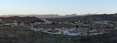
This hill stands out above the "English" settlements of Limaria and Los Higuerales, located within the municipality of Arboleas. It is an isolated hill with some prominence, and therefore, despite its modest altitude, it offers good panoramic views over the eastern part of the Almanzora Valley.
A popular little song makes reference to this mountain:
On Limaria hill there was a rabbit,
which if it hasn't been killed yet must be old...
Although other versions place the rabbit in the neighboring Oria ravine and not on the hill we are dealing with.
From Los Higuerales
Starting from the La Loma neighbourhood of Albox, we continue towards Aljambra along a narrow road that then leads to the hamlets of Limaria and Los Higuerales, a kind of newly created satellite settlement inhabited mainly by British people. About 100 meters before crossing the Rambla del Peral to enter Los Higuerales, we turn right onto a dirt track and park in a small widening (460 m).
We continued along the track towards a nearby farmhouse, which we left to our right. Shortly after, we left the path and headed straight ahead (SE) towards some small terraces, barely large enough for a single tree per terrace. We then proceeded parallel to a ravine (SW) and ascended the ridge of a small hill where a faint path became clearer as we gained altitude. To our right was an antenna situated halfway up the slope.
We are approaching the rocky buttresses that defend the northwestern sub-peak of the hill. To the right of the larger crags, a weak point is visible, and we head towards it. The terrain becomes steeper and the path fades, with occasional cairns guiding us towards a small gully which we climb without particular difficulty to the upper plateau, emerging very close to the NW summit (678 m) (0.35). We descend slightly towards the col that separates us from the main peak, trying to lose as little altitude as possible (662 m), and continue along a path (marked with hunting reserve signs) to a small platform from which the summit, marked by a geodetic vertex (705 m) (0.45), is quickly reached.
For the return, we head back towards the platform and, instead of crossing it, we take a path that descends to the right and then skirts the rocky barrier of the false summit (678 m) on the opposite (east) slope from the route described for the ascent. The path avoids other, smaller rocky areas and finally leads to the Rambla del Peral. Turning left, we follow the dry riverbed (track) to the entrance of Los Higuerales and return to the starting point via the Limaria road.
Alternative ascent route: Instead of leaving the initial track after passing the farmhouse, we can continue along it to the vicinity of the antenna mentioned earlier, which is located halfway up the slope. We approach this installation and continue towards the rocky walls of the hill. Following faint paths or going cross-country, we eventually rejoin the first route to the summit.
Access: Los Higuerales (45 min)

